The ground beneath Swords changes abruptly once you cross from the elevated limestone till around Applewood into the softer alluvial clays flanking the Broadmeadow. A foundation solution that works near the Pavilions may be completely inadequate for a site a kilometre east. Exploratory test pit investigation cuts through that uncertainty. An excavator opens a trench to 4.5 m depth, exposing the sequence of made ground, gravel lenses and stiff Dublin boulder clay so the responsible engineer can log, photograph and sample the strata directly. No indirect geophysics. No disturbed cuttings. Just the actual soil profile visible in sunlight. For sites where a CPT test would struggle with cobbles, the test pit provides a practical alternative.
A logged test pit in Swords glacial till provides a stratigraphic record that no borehole log alone can match — because the geotechnical engineer stands inside the excavation and sees the contacts.
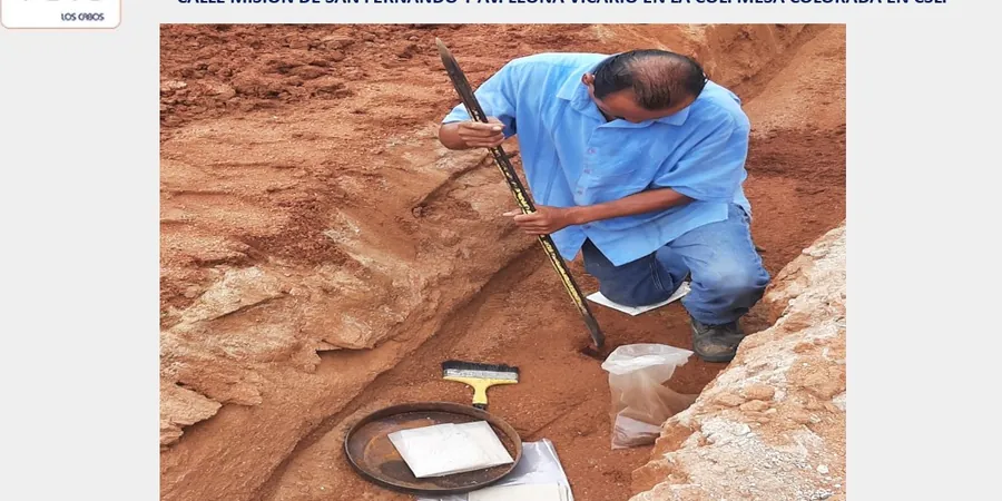
Methodology and scope
IS EN 1997-2:2007 requires that the ground investigation report include a description of all strata encountered — not an interpretation, but a logged observation. In Swords, where glacial deposits alternate unpredictably between dense lodgement till and water-bearing sand channels, that requirement becomes operationally critical. A single test pit can reveal perched groundwater at 1.8 m, a desiccated crust in the upper 600 mm, and a sudden transition to sandy gravel at 3.2 m — all within the same vertical face. The excavation is benched or battered for safe entry. Bulk disturbed samples are taken at each change of stratum, bagged and labelled on site. Undisturbed block samples can be carved from cohesive layers. Depth to bedrock is measured when the excavator bucket hits refusal on limestone. The logged profile is later correlated with nearby borehole records from the GSI database, giving the design team a continuous ground model.
Applicable standards
IS EN 1997-2:2007 (Eurocode 7 — Ground investigation and testing), IS EN ISO 14688-1:2018 (Identification and classification of soil), IS EN ISO 22475-1:2006 (Sampling methods and groundwater measurements), Safety, Health and Welfare at Work (Construction) Regulations 2013 (S.I. No. 291/2013), BS 5930:2015 (Code of practice for ground investigations — referenced in Irish practice)
Frequently asked questions
What depth can a test pit reach in Swords ground conditions?
A standard 13-tonne excavator reaches 4.5 m in stable ground. In Swords, refusal on limestone bedrock or large glacial erratics can limit depth to 2.5-3.0 m in some locations. The geotechnical engineer decides on final depth based on the logged profile and the project's zone of influence.
How long does a single test pit investigation take?
Mobilisation, excavation, logging, sampling and backfill typically complete in 4 to 6 hours for one pit, assuming no delays from groundwater or buried services. A programme of three pits on a Swords residential site is usually finished within two working days.
What safety measures apply when entering a test pit?
Entry is only permitted after the competent person has inspected the face for tension cracks and instability. Excavations deeper than 1.25 m are benched or battered. Confined-space protocols — gas monitor, harness, tripod and top-man — apply if the pit is deeper than 1.5 m and narrower than 1.2 m.
What does an exploratory test pit cost in the Swords area?
For a single machine-dug test pit with full logging, sampling and a factual report, budgets fall between €460 and €650. The final figure depends on access constraints, spoil removal requirements, and whether standpipe installation is included.
Can test pits replace boreholes for a foundation design in Swords?
They complement each other. A test pit gives a continuous exposed profile and large-volume samples but is depth-limited to about 4.5 m. Boreholes reach deeper strata and allow SPT N-values. On Swords sites with shallow bedrock or complex glacial sequences, we use both methods and correlate the logs into a single ground model.