← Home · Underground Excavations

Soft Ground Tunnelling Analysis in Swords: Geotechnical Certainty Before You Break Ground

Together, we solve the challenges of tomorrow.

LEARN MORE →

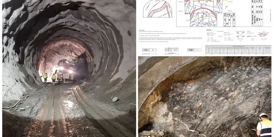
The North Dublin lowlands don't forgive assumptions. In Swords, where glacial till meets alluvial gravels and the water table sits barely two metres below street level, opening a tunnel face without a rigorous geotechnical model is a project-ending gamble. The mix of Dublin Boulder Clay—stiff, overconsolidated, but riddled with lenses of sand and silt—creates a tunnelling environment where ground behaviour can shift in the space of ten metres. Our lab in Swords runs the full sequence: advanced triaxial testing to capture undrained shear strength, consolidation tests that predict long-term settlement under the M1 corridor, and permeability profiles that feed directly into your TBM or SEM design. Pairing site-specific data with in-situ permeability measurements gives you the pore-pressure picture you actually need, not a textbook assumption. We also cross-check stiffness profiles with MASW surveys to map shear-wave velocity across the tunnel alignment, making sure the deformation model matches what the ground will really do when you excavate.

Stiff Dublin Boulder Clay can stand unsupported for hours—until it can't. The pressurised sand lenses hidden inside it are what turn a stable heading into a collapse in minutes.

Methodology and scope

The glacial stratigraphy under Swords is notoriously inconsistent. The Boulder Clay here—formally the Blackrock Formation—weathers to a stiff, fissured matrix with embedded cobbles, but it's the interbedded sand and gravel lenses that cause the real headaches. These lenses are often pressurised, and when a cutterhead hits one, the inflow can destabilise the face and trigger surface settlement before anyone reacts. Characterising this sequence means going beyond standard SPT refusal counts. We run multi-stage triaxial tests on undisturbed samples to define the Cam Clay parameters and small-strain stiffness that every FE modeller needs. The test pits we log across the alignment let us map the weathered crust depth precisely, because the transition from stiff clay to hard lodgement till changes the peak friction angle by several degrees. Consolidation testing at in-situ stress levels—not just 200 kPa—is what separates a reliable lining design from one that cracks. And when the alignment passes under the Ward River floodplain, we use resistivity tomography to trace the water-bearing channels before the first shovelful of muck comes out.
Soft Ground Tunnelling Analysis in Swords: Geotechnical Certainty Before You Break Ground
Technical reference image — Swords

Local considerations

The most common mistake on Swords tunnelling projects is treating the Boulder Clay as a homogeneous, impermeable unit. It isn't. Contractors who skip detailed pore-pressure profiling misjudge the face pressure needed for the TBM, and the result is either blowout or uncontrolled settlement that cracks houses along the R132. Another recurring failure: designing segmental linings using generic stiffness parameters that ignore the clay's anisotropy. The horizontal stiffness in this material can be half the vertical value, and if your structural model doesn't reflect that, the rings distort under load. The third trap is assuming the water table is static; the Ward River valley creates a perched aquifer that rises fast after heavy rain, and a deep excavation monitoring scheme that isn't tied to real-time piezometer data is blind. We've seen headings flood where the ground investigation report said "dry conditions expected."

Need a geotechnical assessment?

Reply within 24h.

Email: contact@geotechnical-engineering.co

Technical parameters

ParameterTypical value
Undrained shear strength (su) – Boulder Clay60–250 kPa (depth-dependent)
Small-strain shear stiffness (G0)Derived from MASW Vs30 & triaxial bender elements
Permeability (k) – sand/gravel lenses1×10⁻⁴ to 1×10⁻⁶ m/s
Permeability (k) – intact Boulder Clay matrix1×10⁻⁹ to 1×10⁻¹⁰ m/s
Atterberg limits – typicalLL 30–45%, PL 15–20%, PI 15–25
Groundwater level (Swords area)1.5–3.5 m below ground surface (seasonal)
Overconsolidation ratio (OCR)8–20 (upper 15 m)

Associated technical services

01

Tunnel Alignment Ground Model

Integrated geological, hydrogeological and geotechnical model along the full drive length, combining borehole logs, lab data and geophysics. Delivered as a 3D Leapfrog or Civil 3D-compatible dataset with interpreted cross-sections at 20 m intervals.

02

Advanced Laboratory Testing Suite

CIU and CAU triaxial, oedometer at in-situ stress, ring shear for residual strength on fissured clay, and bender element tests for Gmax. All testing to IS EN ISO 17892, run in our Dublin-area lab with 14-day standard turnaround.

03

Pre-Construction Pore Pressure Study

Installation and monitoring of standpipe and vibrating-wire piezometers across the alignment, with real-time data logging. Includes seasonal baseline reporting and rainfall-response analysis critical for EPB face-pressure calibration.

Applicable standards

IS EN 1997-1:2005 + NA (Eurocode 7 – Geotechnical design), IS EN 1997-2:2007 + NA (Ground investigation and testing), IS EN ISO 17892 series (Laboratory testing of soil), IS EN ISO 22476-1 (CPT), ITM Spez 5.05.04 TF (Tunnel face stability – Irish Tunnelling Manual)

Frequently asked questions

What soil conditions make tunnelling in Swords difficult?

The main challenge is the Dublin Boulder Clay—stiff, overconsolidated, but containing water-bearing sand and gravel lenses at unpredictable depths. These lenses are often under artesian pressure, so encountering one during excavation can cause sudden water inflow and face instability. The upper 3–4 metres is typically weathered, fissured clay with lower strength. Groundwater is high, especially near the Ward River, and fluctuates seasonally.

What laboratory tests are essential for a soft-ground tunnel in glacial till?

At minimum: CIU triaxial tests to establish undrained shear strength profiles at several depths; oedometer consolidation tests at in-situ stress levels for settlement prediction; Atterberg limits to classify the clay fraction; and particle size distribution to characterise the granular lenses. For FE modelling we add bender-element or MASW-derived small-strain stiffness and ring-shear tests to capture residual strength on fissured surfaces.

How much does a tunnel geotechnical investigation cost in the Swords area?

A comprehensive ground investigation for a soft-ground tunnel alignment in Swords typically ranges between €4,260 and €14,660, depending on the number of boreholes, the depth of the drive, the laboratory testing programme, and whether geophysical surveys like MASW or resistivity are included. Shallow utility-tunnel studies fall at the lower end; TBM drives under the M1 corridor with full lab suites run higher.

How do you handle the transition between weathered and intact Boulder Clay in the tunnel model?

We log the transition depth in each borehole and test pit using SPT refusal, pocket penetrometer readings, and visual inspection for fissuring and oxidation. The weathered zone is assigned lower stiffness and higher permeability parameters. We then interpolate the transition surface across the alignment in a 3D model, so the tunnel designer can segment the lining loads accurately along the drive, avoiding under-design in the critical portal zones.

Location and service area

We serve projects across Swords and its metropolitan area.

View larger map