Swords sits on a geological divide that influences every foundation poured across the town. Moving west toward the Ward River valley, the subsoil shifts from the stony tills of the Dublin plateau into softer alluvial silts. That transition—from a well-graded granular deposit to a fine-grained basin fill—demands more than a basic classification. A complete grain size analysis, combining mechanical sieving for the coarse fraction and hydrometer sedimentation for fines below 75 microns, reveals the full distribution curve that governs permeability, frost susceptibility, and compaction behavior. Without that curve, a contractor importing granular fill for the new residential schemes along Rathbeale Road cannot verify the material meets the Department of Transport specification for Class 6F2 capping. The same test, applied to natural ground near the Broadmeadow estuary, detects the silt content that triggers soft ground remediation before a strip footing is even designed. In Swords, where infrastructure spending continues to track Fingal County Council’s development plan, the atterberg limits test complements the particle size curve by linking the fine fraction to plasticity, while proctor tests use the gradation to establish the moisture-density relationship for controlled fill placement.
A sieve-only PSD can miss 20 percent fines in Swords glacial till—enough to misclassify the fill and trigger a bearing failure.
Local considerations
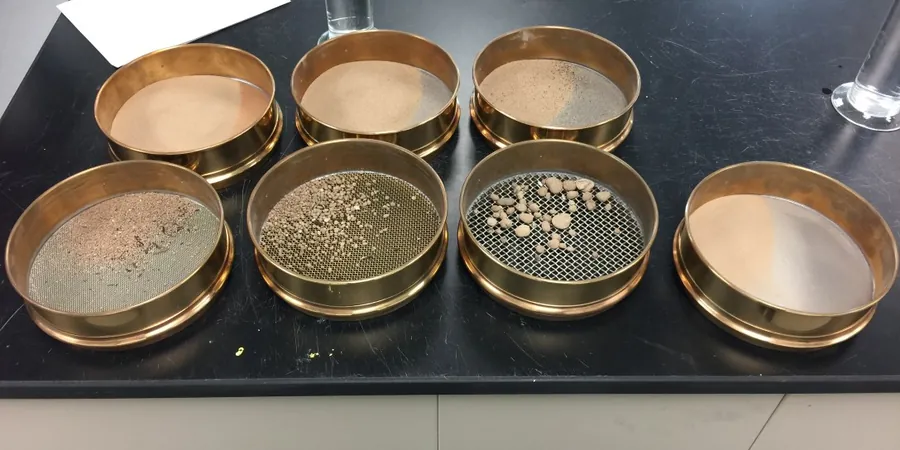
The laboratory layout for a combined grain size analysis starts with a stack of 200 mm brass sieves on a mechanical shaker, running for 10 to 15 minutes to separate the coarse fraction. The material passing the 63-micron sieve is collected as slurry and transferred to a 1000 mL glass cylinder for the hydrometer reading. In Swords, where the winter groundwater table sits barely a metre below ground level across the Ward River floodplain, the fine fraction often includes organic silts that require pre-treatment with hydrogen peroxide to prevent flocculation. The hydrometer is lowered into the suspension at timed intervals—0.5, 1, 2, 4, 8, 15, 30, 60 minutes and onward—with temperature corrections applied to each reading. A common risk on fast-tracked Swords school extension projects is the client submitting a sample with insufficient fines for a valid hydrometer test; the lab then requests a larger bulk sample, delaying the earthworks specification by three days. The combined curve, plotted on a semi-logarithmic scale, also serves as the primary screening tool for liquefaction susceptibility in saturated granular layers beneath the M1 interchange.
Frequently asked questions
What does a combined grain size analysis cost for a Swords site?
A combined sieve and hydrometer test runs between €90 and €160 per sample, depending on the number of sieves requested and whether pre-treatment for organic content is needed. Standard dry sieving alone sits at the lower end of that range.
How much sample material do I need to send to the lab?
For a combined analysis, we require 2 to 5 kg of undisturbed bulk material. If the maximum particle size exceeds 37.5 mm—common in Swords till with cobble content—a larger 10 kg sample ensures the coarse fraction is representative.
How long does the hydrometer phase take before the final report is issued?
The hydrometer sedimentation readings run over a minimum 24-hour period, with the full combined report typically delivered within three working days of sample receipt. We can expedite a preliminary grading curve from the sieve phase on the same day if the project is on a tight earthworks deadline.
Can the grain size curve tell me if my fill is frost-susceptible?
Yes. The percentage passing the 63-micron sieve is the primary indicator. Under Irish earthworks practice, a material with more than 15 percent fines is considered frost-susceptible and may require a capping layer or geotextile separation in unheated structures. The full hydrometer curve quantifies that fraction precisely.