← Home · Seismic

Seismic Microzonation Studies in Swords: Ground Response for Safer Development

Together, we solve the challenges of tomorrow.

LEARN MORE →

Swords has grown from a monastic settlement around St. Columba’s Well into one of Ireland’s fastest-expanding urban centres, with the population surpassing 40,000. This rapid transformation puts pressure on land underlain by glacial till and the occasional pocket of soft alluvium near the Ward River valley. When a planning authority or design team requests a seismic microzonation study, the question is not if Ireland shakes—the Irish National Seismic Network records roughly 200 tremors annually—but how the local ground will amplify that motion. Our geophysical crew brings MASW profiling and downhole seismic methods to map shear-wave velocity across the site, producing the VS30 grids and site-class maps that Eurocode 8 demands. Combined with liquefaction triggering analysis using SPT-based and CPT-based correlations, the study delivers a defensible ground model for bridge, school, and multi-storey residential projects across the Swords area.

Mapping the resonance period of a glacial till basin before laying foundations is cheaper than retrofitting after a low-probability, high-consequence tremor.

Methodology and scope

Swords sits at an elevation of roughly 10–25 metres above Ordnance Datum, draped over a mix of lodgement till, glaciofluvial sands, and thin peat lenses—a legacy of the last glacial retreat. The 1984 Llŷn Peninsula earthquake (magnitude 5.4) was felt across Dublin and reminded engineers that intraplate seismicity, though infrequent, can generate spectral accelerations worth designing for. A proper microzonation campaign here starts with defining the engineering bedrock—often the limestone that underlies the till at depths of 15 to 40 metres. We measure fundamental site period with HVSR, calibrate the velocity model with seismic refraction lines, and validate the results against borehole lithology from SPT drilling logs. The output is a series of ground-motion maps showing peak ground acceleration and spectral ordinates for return periods of 475 and 2475 years, directly usable by structural engineers working in ETABS or SAP2000.
Seismic Microzonation Studies in Swords: Ground Response for Safer Development
Technical reference image — Swords

Local considerations

The tills around Swords are generally stiff, but the hidden risk lies in the isolated lenses of saturated silty sand deposited during deglaciation. Under cyclic loading, these lenses can develop excess pore pressure and lose strength even at PGA values below 0.05g—a scenario that Eurocode 8 part 5 forces us to check for Importance Class II and III structures. The Ward River floodplain and the Broadmeadow estuary edge bring a shallow water table into the equation, amplifying the liquefaction susceptibility. Our field programme addresses this by pairing continuous CPT soundings with seismic dilatometer tests, mapping the cyclic resistance ratio layer by layer. The final microzonation report includes a liquefaction potential index map so the civil engineer can decide where ground improvement—such as stone columns or vibrocompaction—becomes a contractual necessity rather than an afterthought during tender.

Need a geotechnical assessment?

Reply within 24h.

Email: contact@geotechnical-engineering.co

Technical parameters

ParameterTypical value
Measured parameterVs (shear-wave velocity) at 1–30 m depth
Primary methodMASW, ReMi, crosshole, or downhole seismic
Reference standardEurocode 8 EN 1998-1:2004, I.S. EN 1998-1/NA
Site-class outputVS30 class (A–E) per Table 3.1 EC8
Ground-motion parameterPGA, PSA at 0.2s and 1.0s, Arias intensity
Liquefaction assessmentFactor of safety per NCEER/Youd-Idriss (2001)
Typical grid spacing15–50 m depending on structure importance class

Associated technical services

01

VS30 Mapping & Site Classification

We deploy active and passive surface-wave arrays to build a 3D shear-wave velocity model of the site. The final deliverable is a contoured VS30 map and a georeferenced site-class plan that Fingal County Council planners accept for flood-defence schemes, school extensions, and residential masterplans.

02

Ground-Motion & Liquefaction Hazard Assessment

Using the velocity model plus borehole and CPT data, we run one-dimensional equivalent-linear site-response analysis to generate design spectra at the surface. Liquefaction potential is evaluated for each test location, producing a zonation map that clearly flags areas where ground improvement or deep foundations become mandatory.

Applicable standards

I.S. EN 1998-1:2004 + National Annex (Eurocode 8, seismic design), ASTM D7400-19 (downhole seismic testing), ASTM D4428/D4428M-14 (crosshole seismic), NCEER/NSF 1997 (SPT-based liquefaction triggering), Robertson & Wride 1998 (CPT-based liquefaction)

Frequently asked questions

What does a seismic microzonation study cost for a typical site in Swords?

For a site of 1–3 hectares with a single array and supporting boreholes, budgets generally fall between €3,320 and €15,900 depending on the number of geophysical lines, the depth of investigation, and whether we need to bring a CPT rig for liquefaction checks. We provide a fixed-price proposal after a desk-study review of the available GSI mapping.

Is seismic microzonation mandatory for a two-storey extension in Swords?

For a standard dwelling, a full microzonation is rarely required. However, the Building Regulations (Part A, Technical Guidance Document A) reference Eurocode 8, and when the structure falls into Importance Class II or higher—or when the site sits on the soft alluvium near the Ward River—the design team may ask for a site-class determination to justify the chosen ground type and spectral shape.

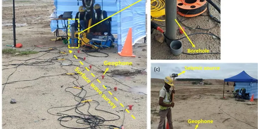
How long does fieldwork take for a microzonation campaign?

For a medium-sized site, we typically need two to three days on the ground. MASW lines, a few seismic refraction spreads, and the calibration boreholes run concurrently. Data processing, dispersion-curve inversion, and site-response modelling then require another two weeks before the draft report is ready.

Can the microzonation results be used directly in my structural model?

Yes. We deliver the design spectra and soil profiles in formats compatible with common structural software. The report explicitly lists the elastic response spectrum parameters—agR, S, TB, TC, TD—per the Irish National Annex so that the structural engineer can input them directly without reinterpretation.

Location and service area

We serve projects across Swords and its metropolitan area.

View larger map