← Home · Geophysics

Electrical Resistivity Testing (VES) Across Swords and North County Dublin

Together, we solve the challenges of tomorrow.

LEARN MORE →

Swords sits on a complex glacial mix that shifts from stiff Dublin boulder clay to pockets of alluvial gravels along the Broadmeadow River corridor, making uniform foundation assumptions risky. With the town’s population now exceeding 42,000 and major developments like Swords Central pushing into former greenfield sites, we see a growing demand for subsurface mapping that goes beyond isolated boreholes. Vertical Electrical Sounding fills that gap by profiling resistivity contrasts across a continuous depth range, often reaching 30 to 50 metres below ground level. In our experience, a VES survey run before intrusive drilling helps position exploratory boreholes where they deliver the most geological value, especially when limestone bedrock is suspected at variable depths. We regularly pair this method with a seismic refraction survey when the client needs both velocity stratigraphy and water table depth on the same cross-section, which is particularly useful for commercial schemes near the M1 corridor where cut-and-fill volumes have to be estimated with precision.

A well-planned VES survey in Swords can locate the clay-rock interface within half a metre of its true depth, turning a risky mass excavation into a controlled earthworks operation.

Methodology and scope

A common mistake we encounter on Swords projects is relying solely on trial pits to estimate bedrock depth across a multi-hectare site, because the glacial cover here can hide an irregular rockhead that varies by several metres over short distances. Electrical resistivity provides a continuous profile that reveals this undulation without digging every ten metres, reducing both cost and programme time. The method works by injecting a controlled DC current through steel electrodes and measuring the resulting potential difference, with the Schlumberger array being our default configuration for vertical soundings that need good vertical resolution. We process the apparent resistivity data through inversion software to produce layered models of true resistivity, which our geophysicists then calibrate against borehole logs or test pits to convert ohm-metre values into lithological units: dry granular soils read high, saturated clays read low, and intact limestone spikes the curve dramatically. For brownfield jobs where buried foundations or utilities complicate the picture, we apply quality-control filters that flag coupling anomalies before final interpretation.
Electrical Resistivity Testing (VES) Across Swords and North County Dublin
Technical reference image — Swords

Local considerations

The glacial till blanket across Swords contains lenses of sand and gravel that can act as confined aquifers, especially where the underlying bedrock forms a shallow depression. If these water-bearing layers are missed during a desk-study-only investigation, contractors hit groundwater inflows during excavation that slow the programme and require dewatering measures not priced in the tender. Resistivity surveys detect these lenses as distinct low-resistivity zones before a single machine tracks onto site, because saturated granular material conducts current far better than the surrounding dry till. We have seen several projects near the Ward River valley where a VES line across the footprint identified a previously unmapped palaeochannel, and the design team was able to adjust the foundation type from pad footings to a reinforced mat foundation that bridged the softer zone without last-minute redesign costs.

Need a geotechnical assessment?

Reply within 24h.

Email: contact@geotechnical-engineering.co

Technical parameters

ParameterTypical value
Array configurationSchlumberger (vertical sounding) and Wenner (lateral profiling)
Typical depth of investigation30 to 50 m below ground level, depending on AB/2 spread
Measured parameterApparent resistivity (Ω·m), inverted to true resistivity layers
Data processingLeast-squares inversion with smoothness-constrained regularization
Calibration referenceBorehole logs, trial pit logs, or dynamic probing results
Report deliverablesResistivity-depth curves, geoelectric cross-sections, lithological interpretation
Applicable standardEurocode 7 Part 2 (EN 1997-2:2007) and ISRM suggested methods

Associated technical services

01

Vertical Electrical Sounding (VES)

Single-point depth profiling using the Schlumberger array to map layer thicknesses and bedrock depth. Ideal for residential developments and school extensions where budget is tight but the rockhead must be confirmed.

02

2D Electrical Resistivity Tomography (ERT)

Multi-electrode profiling along a line to produce a true cross-section of resistivity distribution. We recommend this for road widening schemes near the R132 where lateral changes in ground conditions are the primary concern.

03

Combined geophysical survey package

VES plus MASW or seismic refraction run on the same grid, giving the design team both stiffness and resistivity profiles. This dual-method approach is frequently specified for Swords logistics centres where slab-on-grade performance is critical.

Applicable standards

EN 1997-2:2007 — Ground investigation and testing, ISRM Suggested Methods for geophysical logging, ASTM D6431-18 — Standard Guide for Using the DC Resistivity Method

Frequently asked questions

What does a VES survey in the Swords area typically cost?

For a standard Vertical Electrical Sounding survey in Swords, budgets generally fall between €580 and €1040, depending on the number of sounding points, the maximum depth required, and whether 2D tomography is included alongside the vertical soundings. We always provide a fixed-price proposal after reviewing the site plan and the specific questions you need answered.

Can resistivity testing distinguish between Dublin boulder clay and weathered limestone bedrock?

Yes, and this is one of the most useful applications of the method around Swords. The stiff boulder clay typically returns resistivity values in the 20 to 60 Ω·m range, while competent limestone jumps above 200 Ω·m. The weathered transition zone between the two shows intermediate values that our inversion software can model as a separate layer, which helps the geotechnical designer decide whether pad footings can bear on the till or need to be socketed into rock.

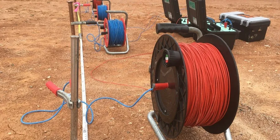
How long does a VES survey take, and will it disrupt site activities?

A single VES sounding takes about 45 to 60 minutes to set up, measure, and pack down, so a typical day on a Swords site allows us to complete four to six soundings. The equipment is entirely surface-based with four steel electrodes pushed a few centimetres into the ground, so there is no drilling noise, no cuttings to manage, and no disruption to concurrent earthworks or surveying crews.

Location and service area

We serve projects across Swords and its metropolitan area.

View larger map